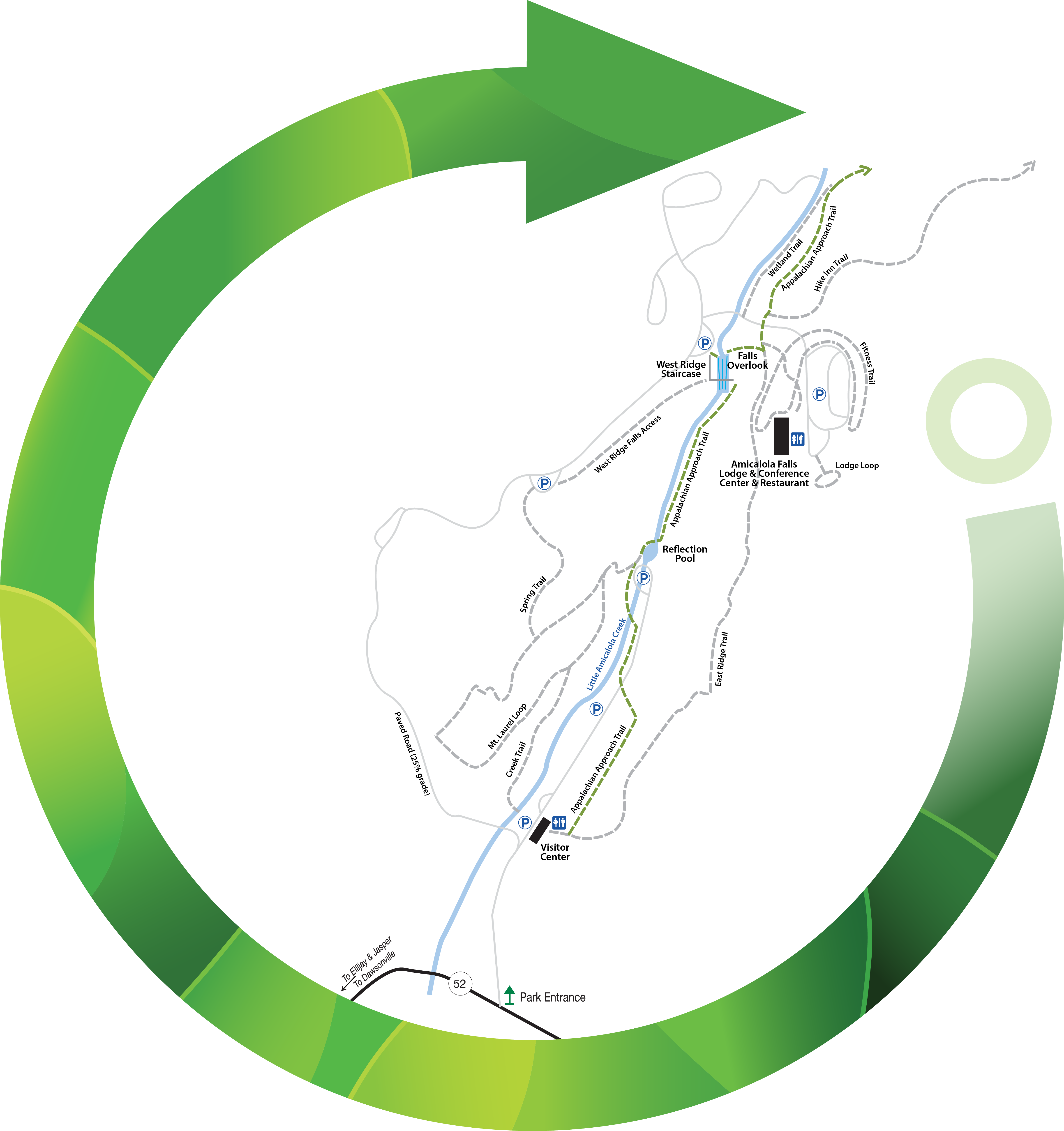
Just past the entrance to Amicalola Falls State Park & Lodge off GA Hwy 52, the Approach Trail begins at the iconic stone archway. The trailhead includes a photo-worthy marker signifying the 8.5 miles to Springer Mountain, the southern terminus of the Appalachian Trail.
As the park’s most popular and scenic route, the blue-blazed Approach Trail follows Little Amicalola Creek to the Reflection Pool and on to Amicalola Falls via a series of stairs and viewing decks. Initially, the trail is relatively flat and easier as it heads toward the Reflection Pool, but picks up significantly thereafter.
This trail in total is Moderate to Difficult due to the steep slope and stairs as it approaches the falls and the terrain once it leaves the park lands. While it is paved in portions below the falls, it may prove too difficult for small children to attempt and is ultimately not suitable for strollers.
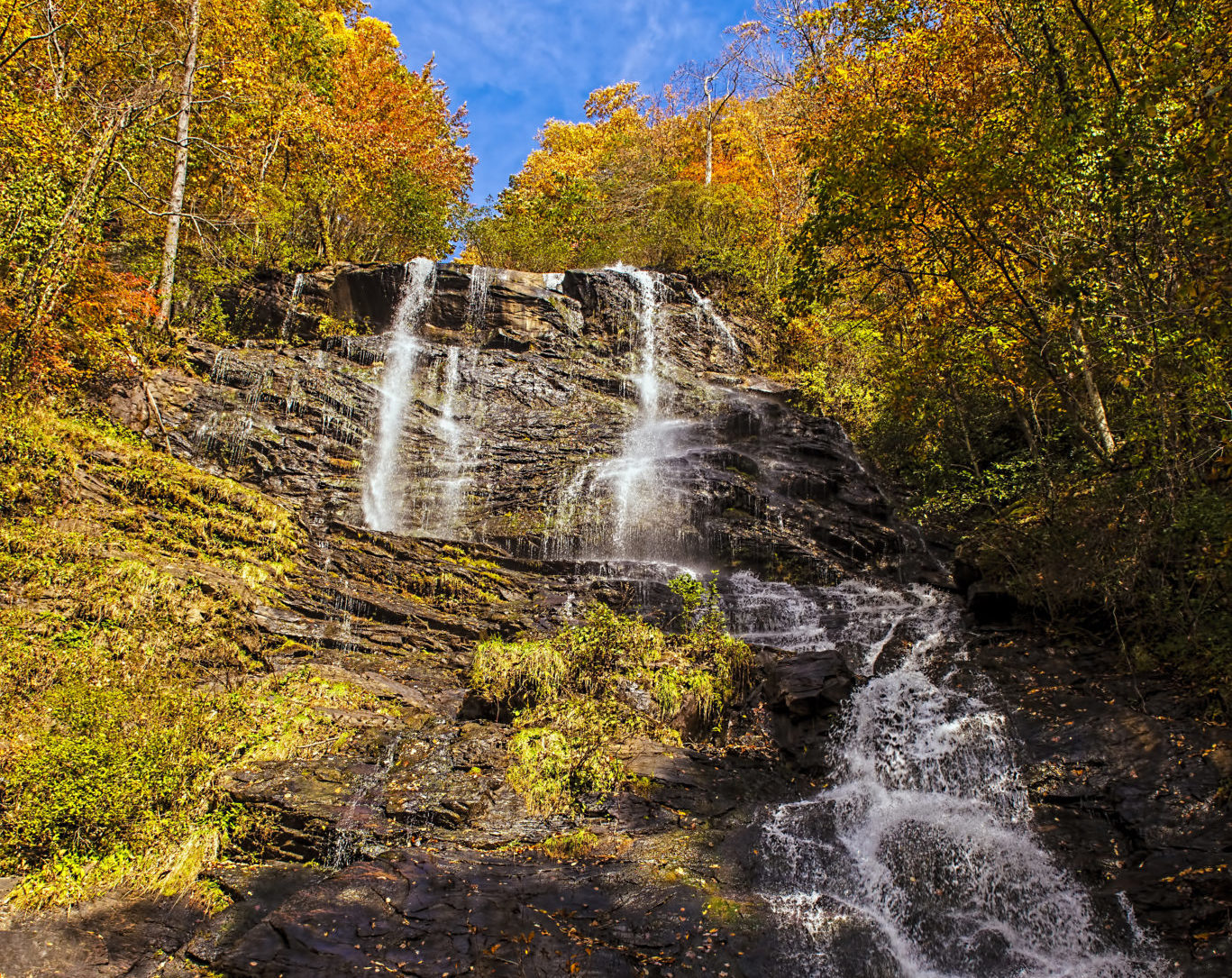
If your breath isn’t already taken away by the 604 steps to the top of the falls, the view of the 729-foot cascade of Amicalola Falls from the foot bridge will do the trick. Upper and lower observation decks give hikers a complete view of the falls. Once the face-to-face meeting with this natural wonder is complete, hikers can use the park’s East Ridge Trail to complete a challenging day-hike loop or enter the Chattahoochee National Forest for the remaining 7.5 miles to Springer Mountain. Hikers seeking the Len E. Foote Hike Inn Trail and its lime-green blazes would also use the Approach Trail, which splits off 0.2 miles after the Lodge parking lot.
Beyond the Amicalola State Park boundaries, the trail serves as a warm-up for AT trekkers starting their long journey. After the split with the Hike Inn Trail, the Approach Trail’s blue blazes guide hikers over a foot bridge and push through a steep climb to the top of Frosty Mountain. Besides a great view, hikers will see the remnants of a long-gone fire tower.
The Len Foote Trail reconnects with the Approach Trail 0.8 miles from Frosty Mountain, after which a 1.5-mile descent through Nimblewill Gap is marked by an intersection with a road of the same name. From there, Springer Mountain is in sight and the trail works its way for 1.5 miles through the wilderness past Black Mountain to Black Gap where an AT-style shelter also sits. The final push rises 600 feet up the south side of Springer Mountain before the reward of exceptional views and the AT terminus.
Once atop Springer Mountain, hikers have three options: continue on the AT, head toward a previously parked car at the lot on FS Road 49, or return south toward Amicalola. Hikers choosing the final option can take the Len Foot Hike Inn Trail back to Amicalola to vary the views or stop by the Inn for a night if reservations have been made in advance. The Approach Trail out and back is roughly 17 miles, while the Hike Inn jog on the return trip would add about 2 miles to the total hike.


 Distance: 8.5 mi
 Difficulty: moderate to difficult
 Directions
; w.print(); )


 2 months ago


