Across the northern part of the state, dozens of waterfalls
cascade down the stone rockfaces of Georgia’s mountainous landscape. Some
waterfalls are easily accessible and can be seen just a short distance from
paved parking lots. Others lie off the beaten path and require a little extra
effort. High Shoals Falls and Blue Hole Falls would be classified as the latter;
however, once you make the trek, the falls will not disappoint.
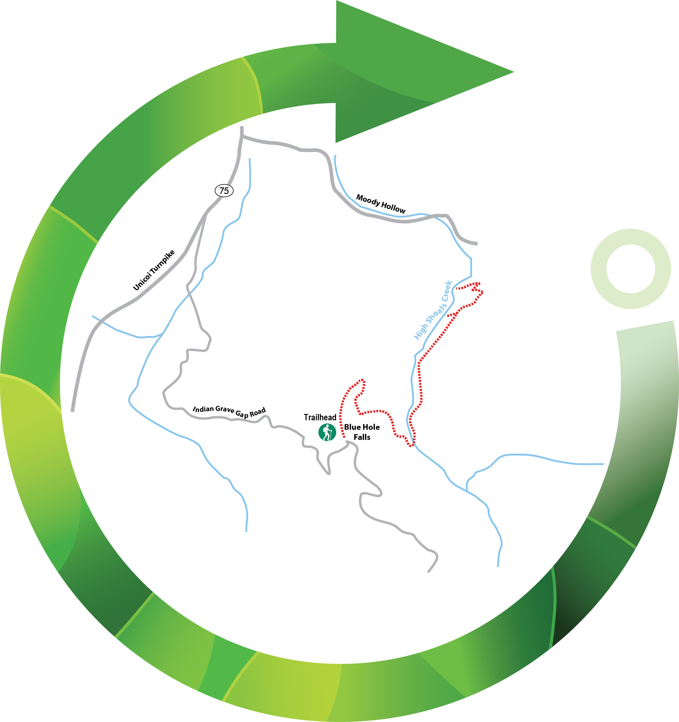
The trailhead is accessible off GA 17/GA 75. Travelling
north on GA 75, the appropriate turnoff to Forest Service (FS) Road 283 is on
the right, 11.4 miles from downtown Helen, Georgia. Southbound travelers coming
from Hiawassee will take a left turn at 9.5 miles, onto FS 283. A sign
indicating the High Shoals Scenic Area should be visible along GA 75 as you
approach from either direction.
Take your time as the turn approaches and do not confuse
residential driveways for FS 283. Simply putting High Shoals Falls into
your GPS may not provide accurate directions to the trailhead. FS 283 may also
be referred to as Indian Grave Gap Road on some maps and GPS devices.
Remember, Forest Service Roads are not maintained the same
as standard paved roads, so you will need to use caution on FS 283. Not only
does the road have several sharp curves, there is a section shortly after the
turnoff that requires vehicles to ford the narrow origins of the Hiawassee
River. The water level varies seasonally and by rainfall; sedans and other low
vehicles may have trouble crossing during times of higher water levels.
Total travel distance on FS 283 to the parking area is a
relatively steep 1.5 miles. The trailhead is near the High Shoals Scenic Area sign,
adjacent to the small parking area. The FS road will continue past the
trailhead and the parking area is easy to miss if no other vehicles are present.
Keep track of your mileage on FS 283 to ensure you stop at the right spot.
The High Shoals Falls Trail is an out-and-back route,
totaling 2.56 miles. While it does change 540 feet in elevation from the
trailhead to the turnaround point on the observation deck of High Shoals Falls,
the trek still falls into the moderate range for most hikers.
Once you leave the parking area, you’ll head down a set of
wooden steps onto the trail. After 0.2 miles, a sharp right will start the
smattering of switchbacks on the trail. The pathway is marked by green blazes,
but the well-worn trail is easy to track, even if your eyes wander to soak in the
wilderness.
You’ll begin to hear the waters of High Shoal Creek well
before the crossing at 0.6 miles.
NOTE: In 2018, the trail bridge crossing High Shoals Creek was damaged by summer flooding. A makeshift bridge has been created by hikers, but as of June 2019, the U.S. Forest Service, which manages the trails within Chattahoochee National Forest, has the trail listed as closed. While the trail is technically closed, access is not restricted, and many hikers continue to utilize the trail.
After crossing the creek, the route will pass a campsite
clearing and follow alongside the rippling water for the next 0.3 miles until
the Blue Hole Falls viewing deck pathway appears on the left. Hikers can choose
to view Blue Hole Falls first or continue to High Shoals Falls, catching Blue
Hole on the return trip.
Blue Hole Falls is a shorter drop than High Shoals, but the power of the water in the 30-foot deluge has created a deep catch pool at the base of the falls, thus the name Blue Hole. Enveloped by rhododendron, the surging water of the falls counterbalances the tranquility of the flora around it. Hikers have been known to dip their toes in the cool water, while being careful of slippery, wet rocks.
Back on the main trail, the pathway descends toward High
Shoals Falls rapidly with two switchbacks leading the way. About halfway to
High Shoals (0.2 miles), a rock shelter that is well known to campers is on the
left. In another 0.2 miles, the trail terminates at the High Shoals Falls
observation deck.
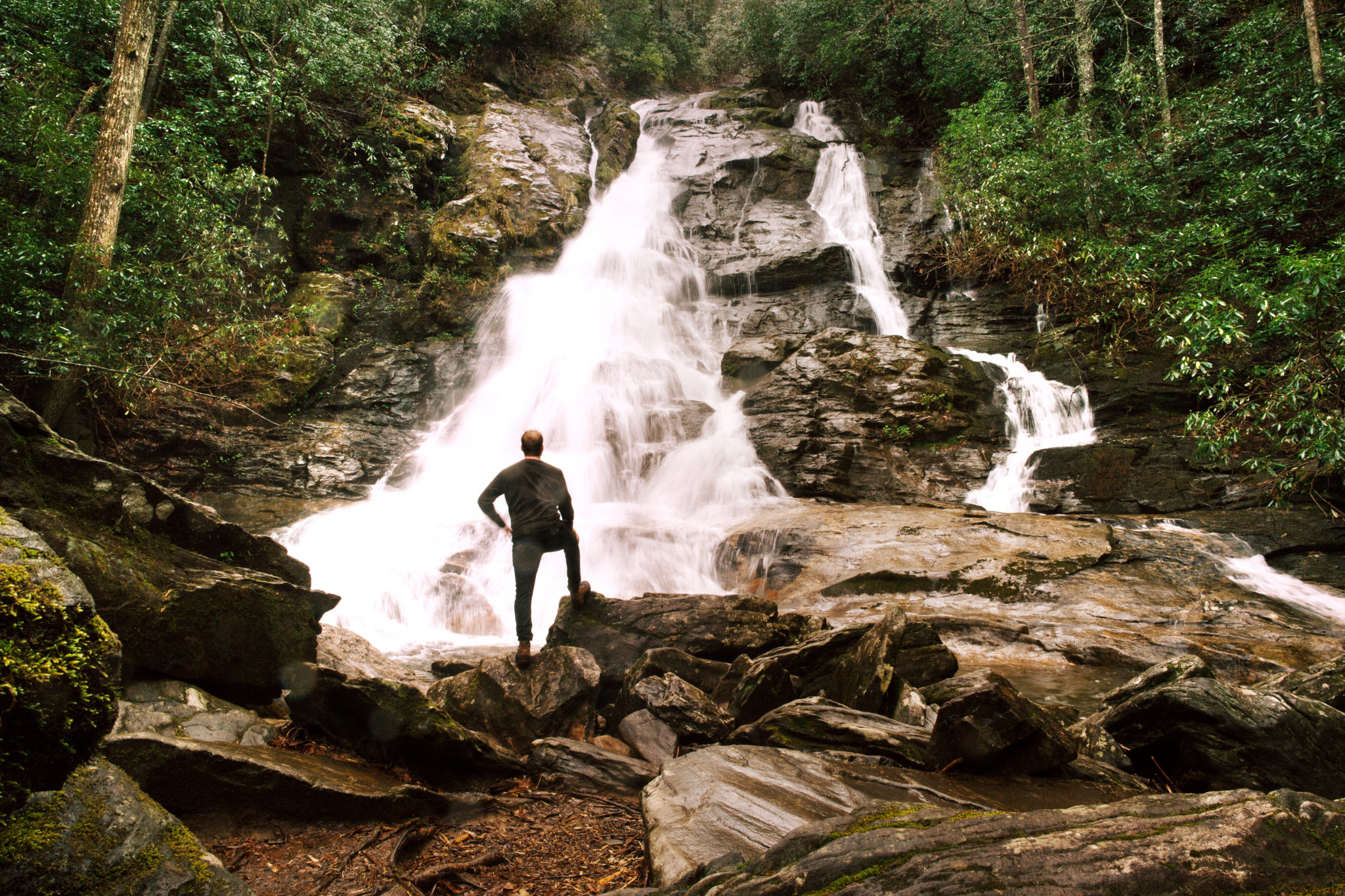
If you’re not immediately in awe of the visual splendor that
is this 100-foot waterfall, the rest of your senses will soon take over. The
sonic quality of the water crashing over the craggy rockface, the reverberation
in your chest due to the proximity to the falls along with the crisp, misty air
should be enough to make the hike worth it.
Although pictures don’t quite capture all the natural
splendor, photo opportunities are plentiful at High Shoals. The way the main
falls and offshoots expand as the water descends helps expand the visual field
and provide great texture. While the falls are framed by tall white pines and elegant
birch, the sky is visible above the falls, which allows for some excellent
photo opportunities at most times of the day year-round.
When you’ve had your fill, follow the same route out to the
parking area, making sure to stop at Blue Hole Falls if you chose to catch it
on the return – or want to see it again. Keep in mind that the 540-foot descent
is now a 540-foot ascent. Although this hike is short, be sure to bring plenty
of water, especially in warmer months, and leave enough daylight to return
before dark if you’re not camping out.


 Distance: 2.56 mi
 Difficulty: moderate
 Directions
; w.print(); )


 2 months ago


