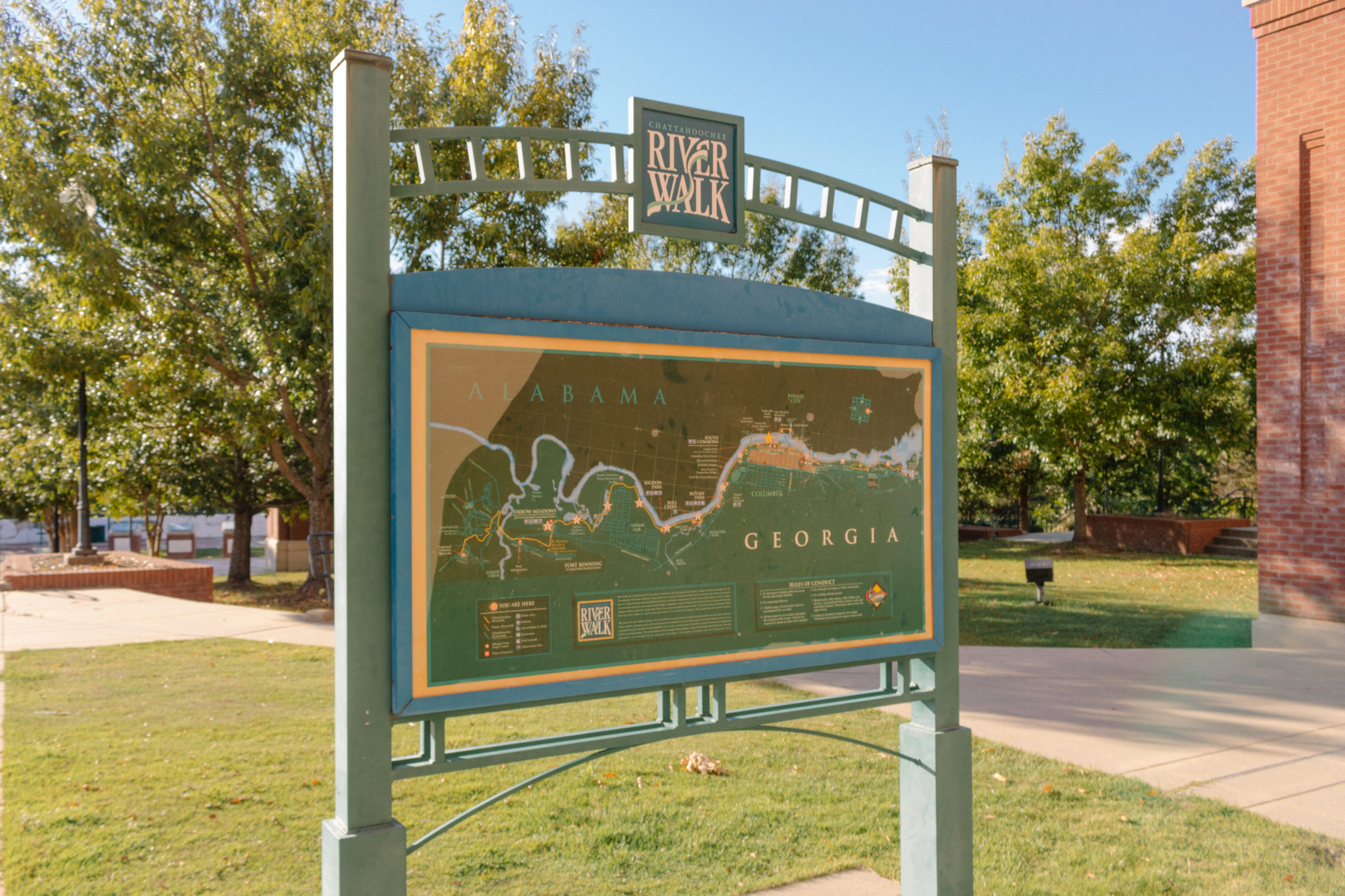
The Chattahoochee RiverWalk in Columbus skirts the banks of
the Chattahoochee River, which follows the border between Georgia and Alabama.
The meandering and hilly paved pathway runs 22 linear miles, linking the quaint
cotton mill village of Bibb City north of Uptown Columbus with Fort Benning to
the south.
Developed as part of the Uptown Columbus revitalization, the
RiverWalk attracts tens of thousands of users every year. After the initial
stretch of trail was constructed in 1992, the RiverWalk steadily expanded. By
1996, the paved trail reached all the way to the main post of Fort Benning,
giving those who travel on two feet or two wheels a blend of cityscapes and
untouched wildlife. The RiverWalk now extends through the campus of
Columbus-based corporation TSYS and into the cotton mill town of Bibb City. It
also is part of the greater Dragonfly Trails network which is slowly but surely
turning old rail pathways into 60 miles of paved paths for bike or foot traffic
that will connect outlying areas with Columbus.
The Chattahoochee River originates in the mountains of North
Georgia and flows to the Florida Panhandle. The river was integral to native
peoples prior to settlement. In the 1800s, commerce flowed through the river
and to Columbus, as steamboats loaded with cotton and other goods pushed
economic development.
Today, the river is an appealing aesthetic component of the
third largest metro area in Georgia. When the weather is warm, pedestrians and
cyclists are likely to see brave participants take on the longest urban whitewater
course in the world that runs right through the west side of Uptown Columbus.
With towering office buildings and chic condos behind them, spectators gather
along the water’s edge to watch groups of rafters and solo kayakers shoot
the rapids. The contrast between cityscape and natural wonder perfectly
encapsulates Columbus.
While the accessible pathway is fit for strollers and
wheelchairs, and the city center is extremely walkable, bicycles will help cover
more ground and explore more of the area via the RiverWalk and other nearby
routes. For visitors to Columbus, several area bike shops have affordable daily
rentals.
Recommended Bike Route: Woodruff Waterfront Park to
Oxbow Meadows Environmental Learning Center, Loop
With ample parking at Woodruff Riverfront Park (1000 Bay
Ave.), this is an ideal place to start and finish. Whether you’re unloading
your personal bike or pulling up on a rental, you won’t be far from the action
of Uptown Columbus.
Woodruff Riverfront Park has restrooms, an amphitheater, a
playground, and a splash pad. The splash pad is free to use, open 7 days a week from
10 a.m.-9 p.m. unless otherwise posted and will be a great way to cool
off after your ride.
Starting from the parking lot at the crest of the riverbank,
navigate the paved sidewalks to the RiverWalk path that runs along the water’s
edge. Once on the path, face south to see Phenix City, AL on the west side of
the river to your right, with Uptown Columbus and the surrounding areas to your
left in the east.
Head south on the path, passing under the Dillingham Street
Bridge in your first 0.2 miles and pass under a railroad bridge at 0.4 miles.
After 0.6 miles, you’ll pass the Coca-Cola Space Science Center and the path
will leave the Uptown Columbus area, becoming more residential along the banks.
After 1.0 mile, you’ll pass under the Route 280 bridge where
the river begins to bend east and in another 0.5 miles you’ll pass the
unmistakable Columbus Civic Center. Around 2 miles in, the National Civil War Naval Museum will
be on the left before the area around the RiverWalk becomes less populated.
Around 4.2 miles in is Rigdon Park. If the full distance of the
recommended trail seems too far, a shorter alternative could be the 8.4-mile
round trip from Woodruff Riverfront Park to Rigdon Park. The fields and pools
of Rigdon Park would provide bikers a chance to stretch their legs and stroll
along the banks of the Chattahoochee before heading back to Uptown.
If you choose to go past Rigdon Park, the Chattahoochee
bends back to the west, exposing a breathtaking natural vista on each side of
the river. The path pulls away from the riverside slightly as it approaches the
Columbus Water Works treatment center and a South Columbus neighborhood at 5.6
miles. The pathway then passes through marshlands, which are teeming with birds
and other wildlife.
At 7.1 miles, the trail, with is heading due east, turns
sharply south. You’ll pass the Oxbow Creek Golf Course and the Columbus City
Dog Park before cruising into the Oxbow
Meadows Environmental Learning Center. The total time for the first leg of
the loop should take around an hour to complete, depending on stops and
sightseeing, of course.
A highlight of the route, Oxbow Meadows helps visitors to
understand the local ecology and wildlife and explore nature trails along
wetlands and ponds. The National Infantry
Museum adjacent to Oxbow Meadows is another great place to stop and tour
if time allows.
Once you’re rested, head back the same way you came, keeping an
eye out for the landmarks you saw on the way down and enjoying the 180-degree
difference in your view. If you still have energy when you reach Woodruff
Riverfront Park, consider heading 0.3 miles north to the Eagle & Phenix Dam
area to watch the whitewater rafters from Waveshaper Island. It’s a must-do
activity in Columbus.


 Distance: 16.8
 Difficulty: Easy to moderate
 Directions


 2 months ago


