Etowah Trail & Sutallee Trace Greenspace Corridor
Initially a Bicentennial project for Cherokee County, the
Etowah Trail & Sutallee Trace Greenspace Corridor is a trail system on a
strip of undeveloped woodland that borders the swift-flowing Etowah River. The land
is owned by the U.S. Corps of Engineers and the Cherokee County Water and Sewer
Authority and is managed by the DNR as a Wildlife Management Area.
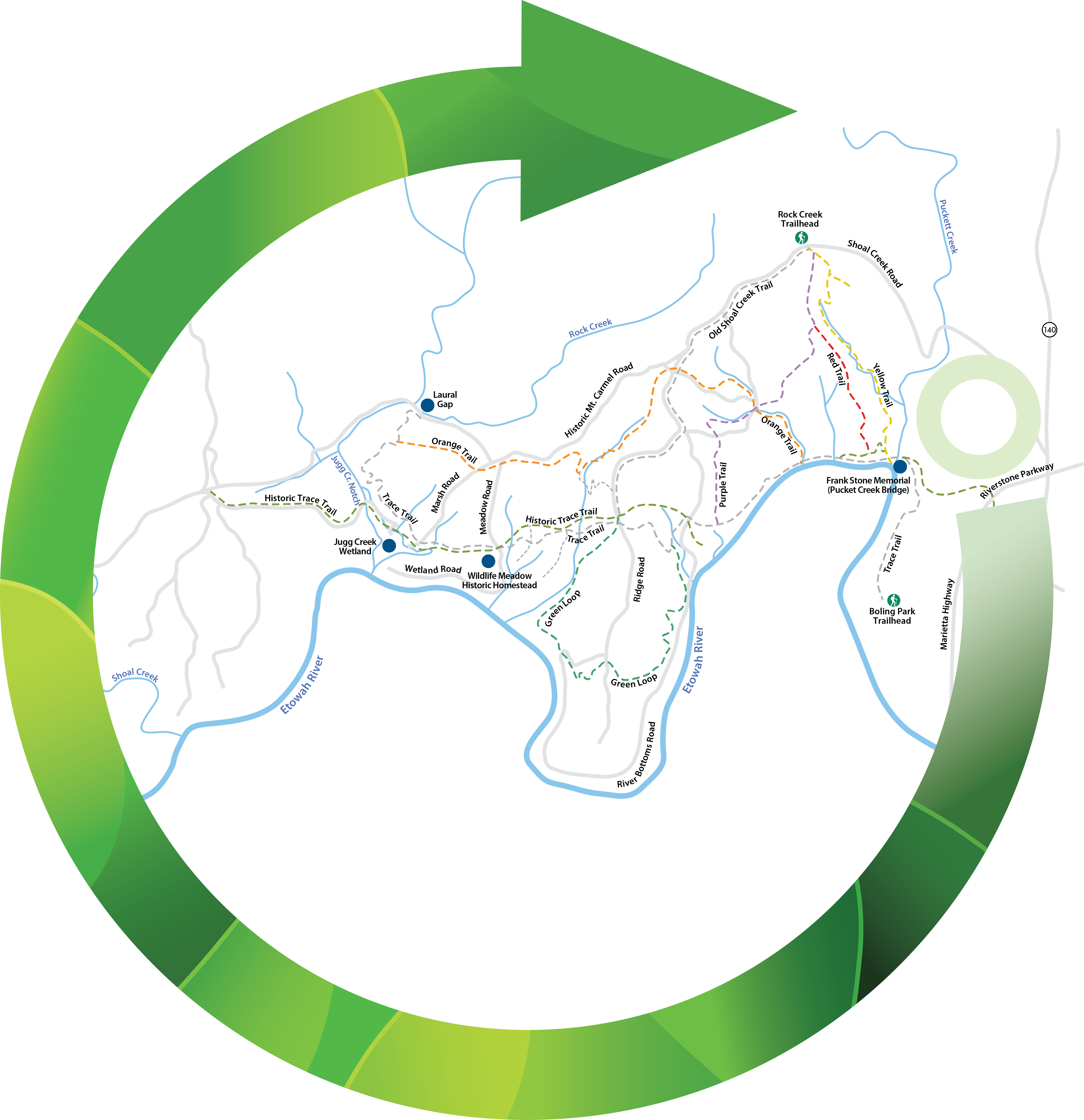
The trail system is anchored by the Trace Trail and Historic
Trace Trail, which overlap in sections. The Historic Trace Trail was used by
the early settlers of Cherokee County. The Trace Trail starts just north of
Cherokee High School in Boiling Park. From there it leads northeast for about three-quarters
of a mile before curving to the west along a section of the Etowah River. The
majority of Trace Trail runs westward from this curve, and all the system’s
loops and trails originate on Trace Trail.
There are two options for accessing the trail system. Hikers
can park at Boiling Park, walk down the gravel path to the back of the park to
reach the Boiling Park Trailhead. From here follow the white blazed Trace Trail
to access all other trails. Trace Trail can also be accessed from the New
Hightower Church Trailhead, which is 2.1 miles down Trace Trail from the
Boiling Park Trailhead.
All trails named after a color are blazed with that color.
Historic Trace Trail and Trace Trail
The trail includes a wooden bridge over Puckett Creek,
scenic views of the Etowah River, native vegetation and wildlife, and the
remaining ends of a stone bridge. These trails are rich with history and run
congruent for portions, giving you the option to follow the Historic 1800s
Canton-Sutallee Trace Route for short spurts where they split. If it is your
first time hiking this trail system, the Trace and Historic Trace Trails are a
great place to start, as all other trails spur from the Trace Trails. You will
have a good sense of the trail system after one observant trip down the Trace
Trails.
Look for remaining signs of early Cherokee County life,
including homesteads, churches, schools, cultivated farmland, and “moonshine”
stills. Abandoned wells and vegetation that is not native to the area indicate
homestead locations. The original road was most likely dug with oxen-powered
tools. There are many points of interests along these trails that remain from
1800s life in Cherokee County.


 Distance: 3.4
 Difficulty: Moderate
 Directions
; w.print(); )


 2 months ago


