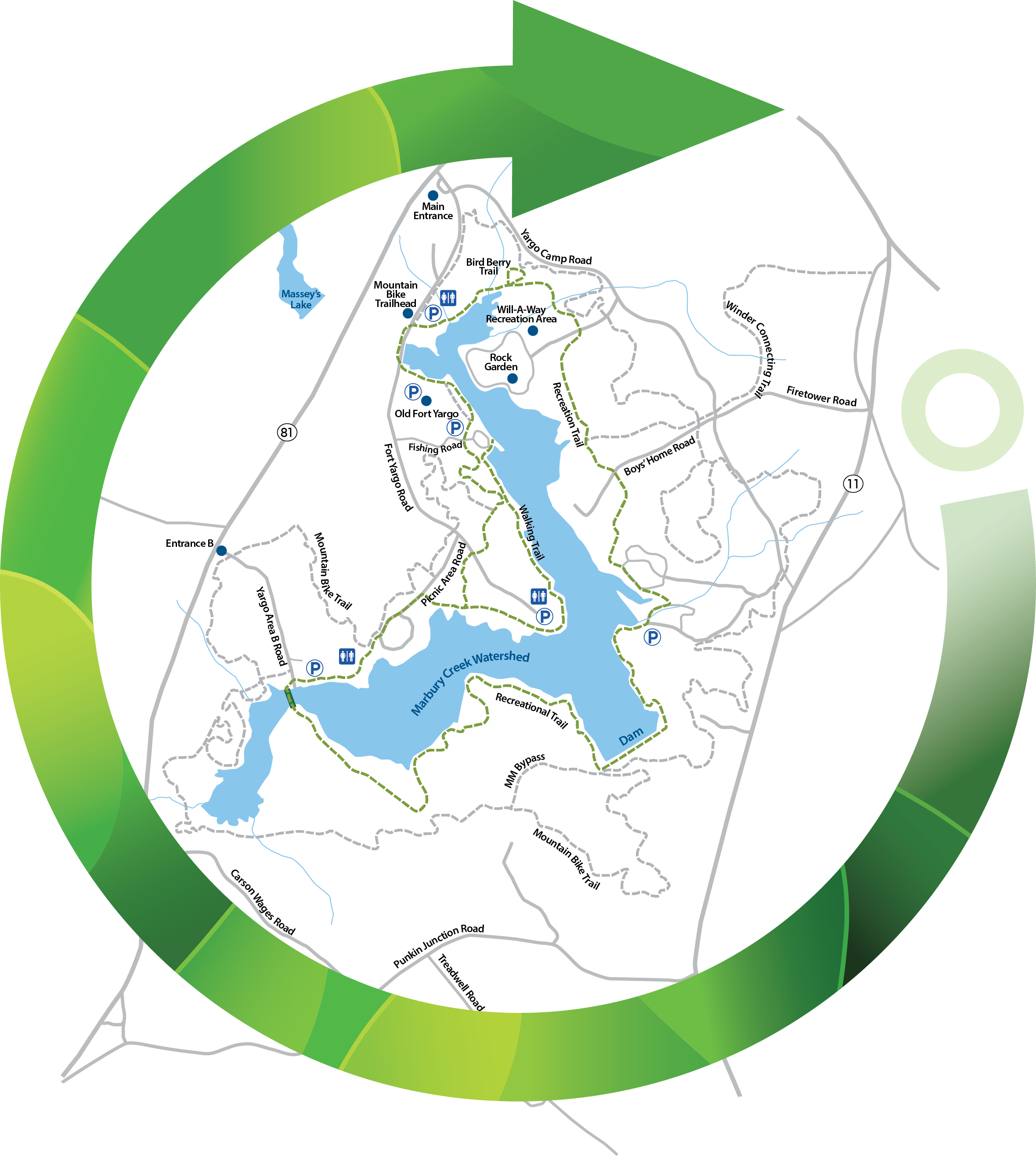
Fit for hiking and biking, this 7-mile mixed use trails hugs the banks of the Marbury Creek Reservoir and provides great views of Fort Yargo State Park. While it is suitable for older kids to hike, biking for those younger than teenagers may prove difficult.
Although the trail is relatively flat, the distance can be deceiving. Pack plenty of water and snacks on this hike, which could last 3-4 hours depending on your pace.
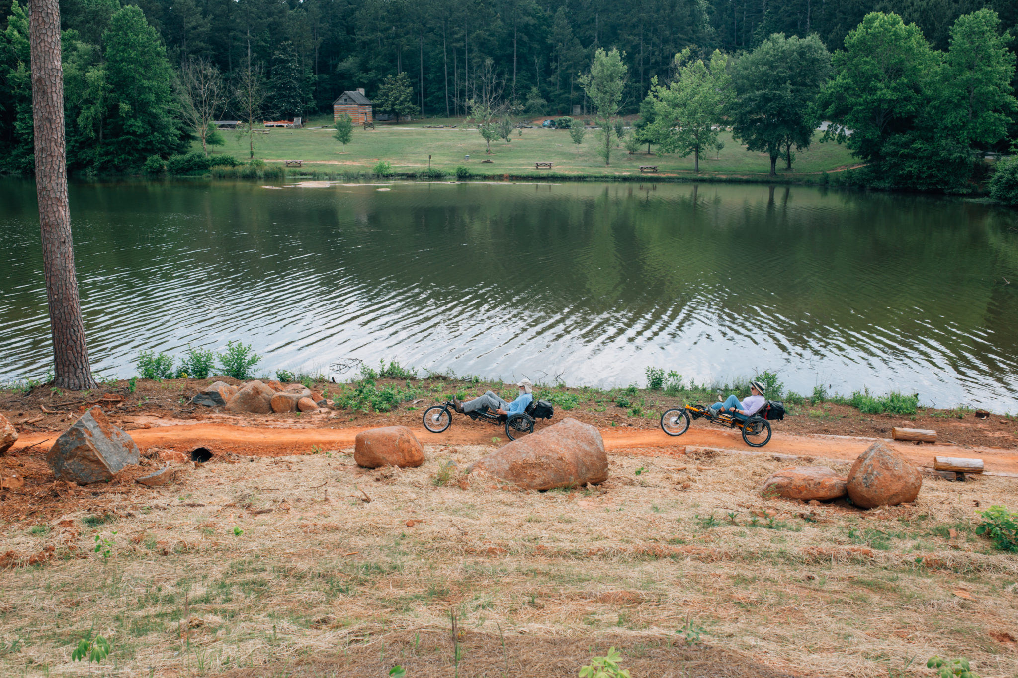
The trail hugs the shoreline in many locations, offering good wildlife viewing. Cyclists and hikers may see white-tailed deer, squirrels, rabbits, raccoons, and turtles. It also travels into wooded uplands for different views of the fauna that populates the forest and underbrush. While on the trail, cyclists should yield to hikers.
Although there are many entry points to the yellow-blazed trail, most hikers and mountain bikers begin at the park’s picnic area, adjacent to the beach. You’ll head southwest along the trail, nearing the lake as you approach the UGA Rowing Boathouse and public boat ramp around 0.35 miles from the start.
You’ll take a left and head south along a wooden foot bridge. With views of Marbury Creek Reservoir from both sides of the bridge, this is arguably one of the most picturesque spots on the entire hike.
Bear left at the end of the bridge and follow the path through two powerline clearings. A crossroads at 0.8 miles in the second clearing signifies a left turn back toward the lake. Follow the shoreline along the peninsula until you reach the earthen dam on the southeast side of Marbury Creek Reservoir at nearly 2 miles.
Below the dam, Marbury Creek flows to the southeast, winding to a confluence with the Apalachee River and ultimately Lake Oconee. Take the trail along the causeway of the dam, turning left to follow the trail north, continuing the counterclockwise route around the lake.
For the next 0.5 miles, hikers and mountain bikers are privy to some of the best sunset views of the lake. Be sure to leave ample time to get off the trail by dark. After you pass the campgrounds, continue north and do not divert from the path. Both the Philip H. Grace Group Home and Camp Will-A-Way are designed for specific groups and are closed to the public.
As you near the park entrance and exit, you’ll pass and eventually connect with the Bird Berry Trail heading west. A foot bridge will direct you toward the Visitors Center where the trail connects with the blue-blazed Mountain Bike Trail.
Heading south, you’ll merge briefly with Fort Yargo Road as you cross a paved bridge. Take a sharp left right after the bridge to follow the trail along the water’s edge. At the junction with Fishing Road, hikers will have the option to stay on the yellow-blazed Lake Loop Trail or take a walking trail that hugs the northwestern peninsula of the lake and meanders just behind the beach area. At this point, the difference in distance isn’t particularly significant and restrooms are nearby if that’s a factor.
Whichever route you decide to take as a hiker, the paths meet back up west of the beach and less than 0.1 miles from the start/finish location at the picnic area.


 Distance: 7 mi
 Difficulty: easy to moderate
 Directions
; w.print(); )


 2 months ago


