Mount Yonah Trail is one of the most popular hikes in White County and has some of the best views in the North Georgia Mountains. Though a difficult hike with a continuous, unrelenting climb to the summit of Mount Yonah, the daytime vistas and sunsets from the summit are truly spectacular.
Besides the sights, the 4.4-mile out-and-back trek is best known for the elevation increase of nearly 1,570-feet from trailhead to summit. Hikers should be prepared for navigating a mixture of surfaces –soil, roots, gravel, and rocky mounds – and may want to consider hiking poles, especially for the steep descent.
Mount Yonah Trail is great for day trips; overnight camping is permitted on Mount Yonah as well. Campsites cannot be reserved, so first-come, first-serve is the way of the mountain. Scope out your spot early. Some hikers and many campers will utilize portable hammocks to take breezy naps in the shade or sleep out under the stars.
Basic restroom facilities are available near the trailhead and about halfway up the mountain, making the 3- to 4-hour journey easier. The mountain is occasionally used for U.S. Army Ranger training, so the clearings that you’ll pass along the way serve as helicopter landing zones from time to time. Due to the exposed rock faces, the mountain is also popular with rock climbers and rappelers. Proper equipment and training are a must to safely execute these activities.
While the trail is listed as kid friendly, parents and guardians should be sure of their child’s abilities. Be sure to pack plenty of snacks and water, and build in time for rest periods. No portion of the trail is lit, so hiking around dusk can quickly turn into a significant challenge if you are unprepared.
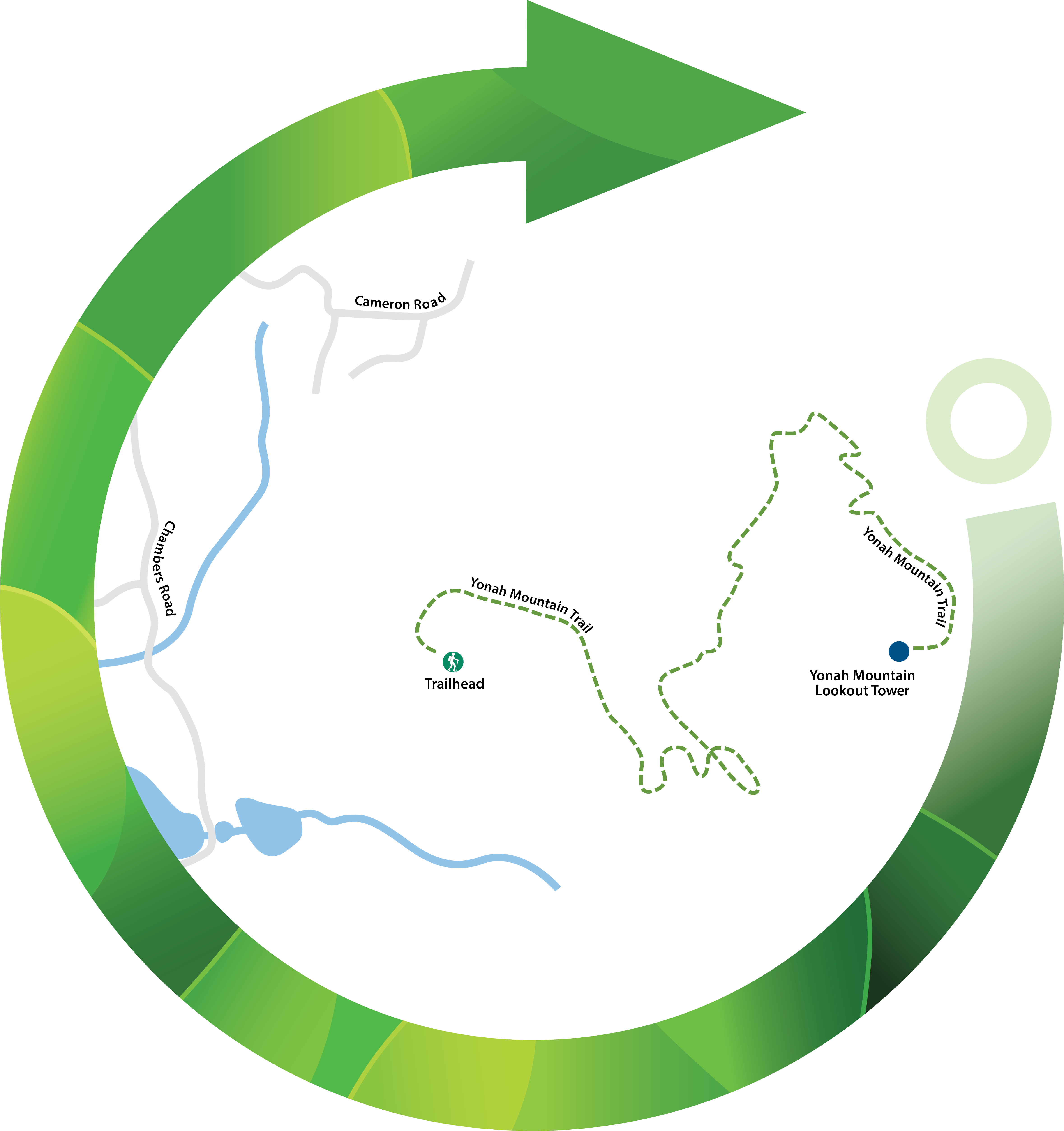
The trailhead sits about 4 miles northeast of Cleveland, Georgia and 6 miles southwest of Alpine Helen, Georgia, the two primary cities of White County. From either direction, navigate to Chambers Road and take Forest Service (FS) Road 323 for 0.3 miles to find the parking lot for the Mount Yonah Trailhead.
Setting out from the trailhead from the west side of the mountain, the steep nature of the climb will soon be evident. Around 0.3 miles, a small bridge guides you over a gurgling stream, after which the trail heads south for 0.2 miles. As the ascent continues, a series of switchbacks begins at 0.5 miles and is followed by an outcropping of rocks that you’ll have to scramble over.
Now heading north, 0.8 miles will be marked by two stone stairs. As you approach the 1-mile mark, keep an eye out for side trails that shoot off the main pathway to rock climbing trails. If you are not planning on climbing, a wrong turn could cost you valuable time on the mountain. The main trail is marked with lime green blazes.
During spring, summer, and early fall, the rocky clearing at 1 mile will likely be lush with wildflowers. It is a good spot to rest and snap a few photos before resuming your Mount Yonah climb.
Another 0.2 miles will bring you to campsites situated around a clearing. The clearing provides westerly views, which are just a sample of what you’ll see at the summit.
Push through along a gravel road, which is now the main trail, and bear right along the gravel road at 1.5 miles. At 1.6 miles, you’ll come upon the Army Ranger camp and continue to follow the road. The lime green blazes should guide you on the right path.
The summit is within reach as you come upon another spot to sample westerly views. A short offshoot around 1.8 miles to an overlook will give you the inspiration you need to complete the journey. Rustic outhouse-style restrooms are not far either.
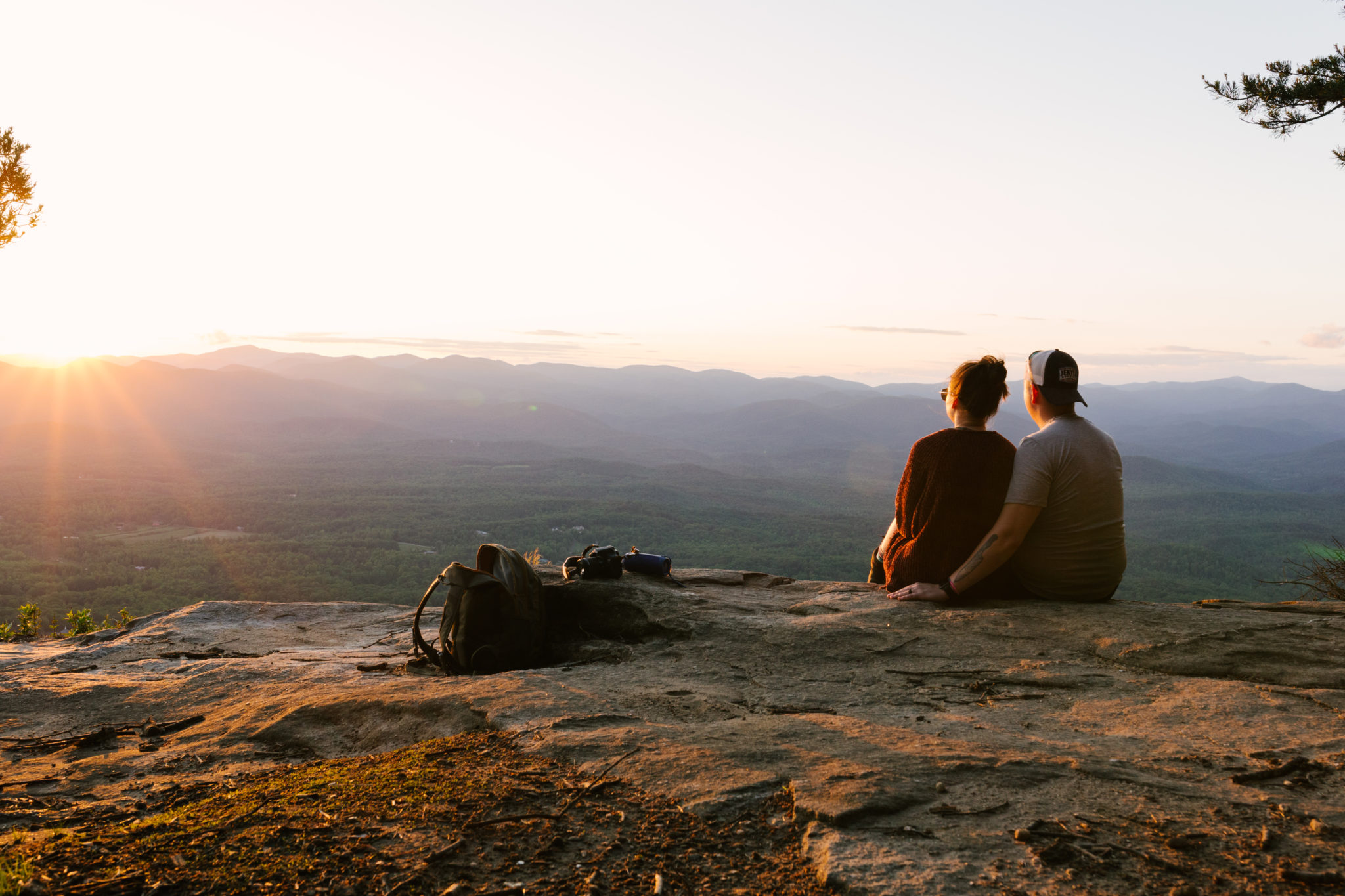
The trail curves around the east side of the mountain before terminating at the summit. The exposed rock and grassy clearings along the trail and near the summit mean that year-round views are abundant no matter how full the leaves are.
Note: The sheer rock faces of the trail’s overlooks are not protected by rails. Hikers should use caution when traversing the summit area and enjoy the views a safe distance from the edge.
On clear days, you’ll be able to see for miles, spotting the foothills of the Appalachian Mountain chain that dot the landscape. Keen observers will note the many farms of White County and fully grasp the importance of agriculture in the local economy.
Sunsets atop the mountain are legendary and the summit at dusk has become a hotspot for amateur and professional photographers. Since there is little light pollution, Mount Yonah is a great spot for star gazing once the sun goes down.
Once you’ve had your fill of the summit vistas, you’ll follow the trail in reverse. For traveling at dusk or later, be sure to have proper lighting (flashlights, headlamps) to guide your way back to the parking lot.


 Distance: 4.4 mi
 Difficulty: moderately difficult
 Directions
; w.print(); )


 2 months ago


