One of the most common routes at Tallulah Gorge State Park,
this recommended trail includes portions of the North Rim Trail, Hurricane
Falls Trail, and South Rim Trail. The pathway, commonly referred to as the
Tallulah Gorge Loop, provides excellent views from 10 overlooks along the edge of
the canyon, as well as in-gorge views along the park’s famed suspension bridge
and Hurricane Falls overlook.
Hikers should note that the Hurricane Falls Trail portion of
this hike has a total of 1,099 stairs, including staircase to gorge floor. The
park requests that you pay special attention to children with you on this hike,
and recommends that those with known health conditions do not attempt this
hike. Additionally, due to the metal stairs, pets are not permitted on the
Hurricane Falls Trail.
Start out heading east along the Interpretive Center Trail
from the parking lot adjacent to the Jane Hurt Yarn Interpretive Center. After
a hundred yards or so, the trail will officially merge with the North Rim
Trail, which you’ll take to overlook No. 1.
While at the first overlook, notice the fallen tower which
was used by famed tightrope walker Karl Wallenda for his 1970 crossing of the
gorge. Heading back the way you came, stay left on the North Rim Trail as the
Interpretive Center Trail goes back toward the parking lot.
Proceed along the springy path made of recycled tires along
the backside of the Interpretive Center until you come to the start of the
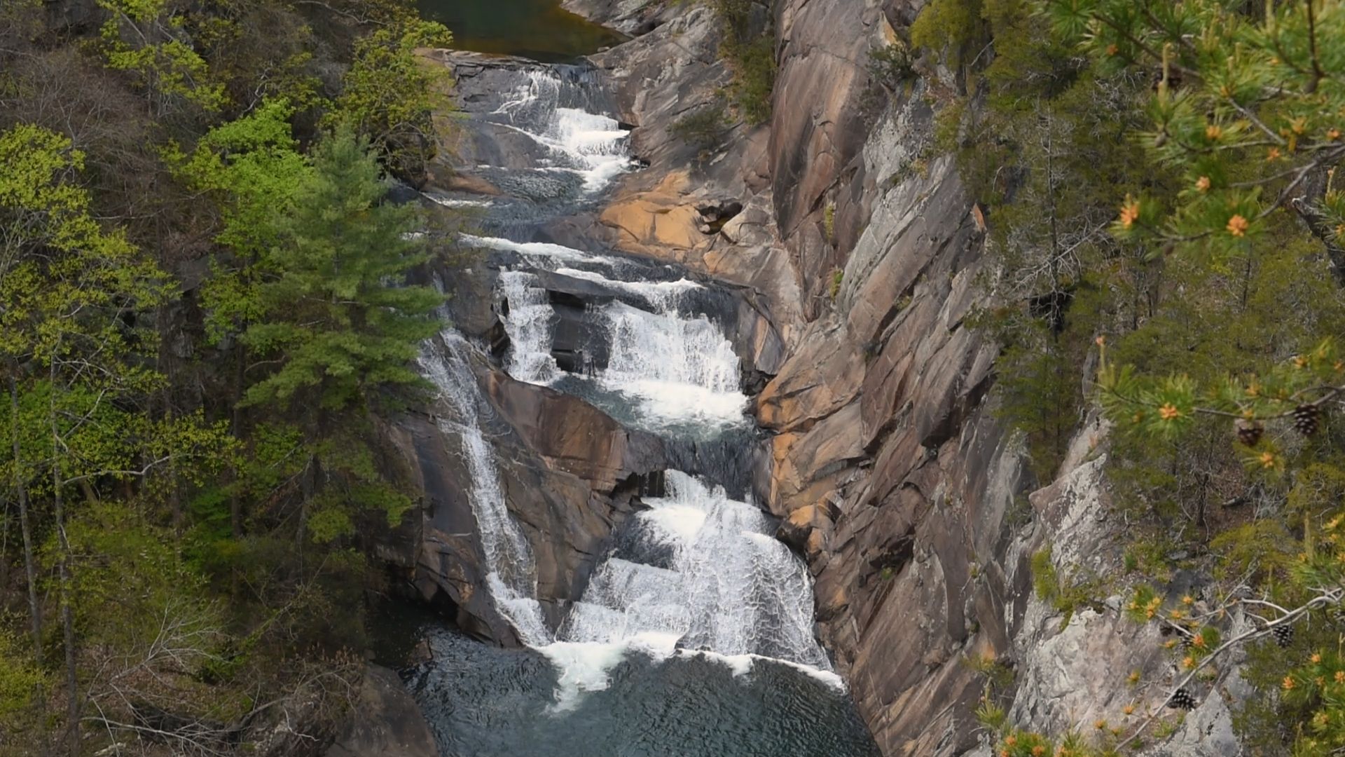
Hurricane Falls Trail. Overlook No. 3 is at this intersection and will provide
views of Ladore Falls, aka L’Eau d’Or Falls, French for “water of gold.”
While maps may make the pathway to Overlook No. 2 and the
suspension bridge seem very close, don’t be fooled. This section is notable for
its descent along roughly 750 manmade steps. Overlook No. 2 has an alternate
view of Ladore Falls and the craggy walls of the gorge. Past the rest stop,
you’ll notice an increase of moisture in the air and the sound of Hurricane
Falls will rise as well.
The remaining steps on the north side of the gorge lead to
the suspension bridge, which crosses the gorge right above the cascade of
Hurricane Falls. For an extra special view, we recommend hanging a left after
the bridge to take the path to the bottom of the gorge. While it requires a few
hundred more steps to get there, the sights and sounds from the Hurricane Falls
overlook are amazing. However, if you’re already feeling tired, consider the
fact that you must climb up the south side of the gorge to the South Rim Trail.
Note: Permits are required past the Hurricane Falls overlook and any trek beyond this point is not part of this recommended hike.
As you ascend the south side of the gorge, dense tree cover
shades your way and several rest area landings are there for you to catch your
breath if necessary. The Hurricane Falls Trail ends at a “T” intersection with
the South Rim Trail. Make a left to visit Overlooks 8, 9, and 10. Overlook No.
8 will give you a view of Hurricane Falls, the suspension bridge, and the north
rim. Overlook No. 9 has a view of Oceana Falls, while Overlook No.10 opens to
Caledonia Cascade and the bluff across the gorge that’s 1,000 feet above the
canyon floor.
Reverse your path and continue along the South Rim Trail as
you pass the Hurricane Falls Trail intersection. After a few hundred yards,
you’ll come to Overlook No. 7 for a view of Tempest Falls and then Overlook No.
6 lies directly across the gorge from Overlook No. 2, just slightly higher.
As you walk long the sun-dappled South Rim Trail you’ll
continue to get closer to U.S. 441 before eventually meeting up with the road
near the Tallulah Falls Dam. You’ll take the pedestrian walkway along the well
trafficked roadway and descend to the North Rim Trail once you reach the other
side of the dam.
Overlook No. 5 has views of the upper gorge while No. 4 puts
the dam front and center. Beyond the dam, which was completed in 1913, you’ll
see the campground and beach of Tallulah Falls Lake. From here, follow the
North Rim Trail over a small creek and past Overlook No. 3 back toward the
Interpretive Center to complete the hike.


 Distance: 2
 Difficulty: moderate to difficult
 Directions


 2 months ago


